A typical fourth grader can rattle off the names of the planets, but does not know the names of the geological chapters of earth history, how old the earth is, when dinosaurs lived, or much else about the history of earth and the life on it. One common excuse for this gap in science education is that these topics are too complicated; but the real reason is the conflict with traditional beliefs — either those of the teacher or of the parents the teacher does not wish to offend. In Ashland, Oregon, the Briscoe Geology Park was built to help students, residents and visitors better understand how our planet and life have changed dramatically through time and how local geology fits into the picture.
In fall 2006, community volunteers proposed to the Ashland School District the construction of a geology park in an unused corner of a closed elementary school. Permission was granted, and with the help of Ashland Parks and Recreation Department, volunteers built the Briscoe Geology Park. The park is designed to operate on multiple levels of ability, such that local university students as well as elementary school students can find it a friendly place to learn a complex subject.
Three "time walks" at the park
explain how earth and life have
changed through time (Figure 1).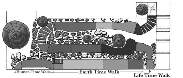 Figure 1
Each time walk is divided into geologic
eons, periods or epochs, as
appropriate. The time walks are
clearly labeled in tile and of an
appropriate length. Hand-made
tiles set into the concrete walkways
(Figure 2) show animal and
plant species representative of
each time interval.
Figure 1
Each time walk is divided into geologic
eons, periods or epochs, as
appropriate. The time walks are
clearly labeled in tile and of an
appropriate length. Hand-made
tiles set into the concrete walkways
(Figure 2) show animal and
plant species representative of
each time interval.  Figure 2Other tiles,
placed at appropriate points along
the time walks, note local geologic
events, mass extinctions, ice ages,
and human and planetary events.
Tracks of trilobites, tetrapods and
dinosaurs show how these animals
moved (Figure 3), and tile plate
tectonic maps depict continental
drift through time.
Figure 2Other tiles,
placed at appropriate points along
the time walks, note local geologic
events, mass extinctions, ice ages,
and human and planetary events.
Tracks of trilobites, tetrapods and
dinosaurs show how these animals
moved (Figure 3), and tile plate
tectonic maps depict continental
drift through time.
 Figure 3
The Earth Time Walk describes the entire 4600-million–year history of earth, and one step along this 20-meter–long path covers about 150 million years. The Life Time Walk covers from the start of the Cambrian Period, 542 million years ago, when multicellular life blossomed, to the present, and each step along this 60-meter–long path covers about five million years. The Human Time Walk describes the most recent 50 000 years of earth history, and one step along this 8-meter path covers about 4000 years. An introductory sign and guideposts introduce visitors to geologic time and the features of the park, and help them navigate between the different time scales of each walk. Other signs note plant species used in the landscaping, and provide information on local rock types. There are also four large interpretive signs, one each to explain local geology, mass extinctions, plate tectonics, and evolution (Figure 4).
 Figure 4
Landscaping along the Life Time Walk follows the evolution of land plants. Along the Cambrian and Ordovician sections the landscaping is bare rock, because land plants (except perhaps for algae) had not colonized the land at that time. Mosses and liverworts, representing the first land plants, appear along the Silurian part of the walk, followed, at appropriate points, by club mosses, horsetails and ferns, cycads, conifers, ginkgo, flowering plants and grasses. In addition, boulders of local rock types are laid out in stratigraphic order across the park, tilted slabs of rock are placed to mimic outcrops of anticlines and synclines, and fossils and interesting rock types are incorporated into retaining walls.
A 20-page color brochure is available at the park for extra-curious visitors. In it detailed descriptions of major events and interesting organisms are provided for each geologic interval. Extra information on plant evolution, mass extinctions, biological evolution, local geology, and plate tectonics is also included. For students, a two-part educational program has been set up by the North Mountain Park Nature Center. First a docent visits the classroom and explains geologic time and how to use the scale bar on a tile to determine the size of the animal depicted. This is followed by a field trip to the park, during which students use information at the park to discover earth history. Discovery is helped along by multi-page activity sheets that students fill out at the park. There are three sets of activity sheets, one each for elementary, middle and high school grade levels. A 55-page teacher's guide gives educators detailed information on all aspects of the park.
Reaction so far has been very positive from the schools and the community. We hear that the artwork of the tiles, the lush landscaping, high quality rock work, and the interpretive signs combine to make the Park a pleasure to visit and the science fun and interesting to learn. Readers are cordially invited to visit Ashland and the Briscoe Geology Park.